imagery viewer template
1.0.0
With the Imagery Viewer configurable template, create apps to visualize and interpret imagery layers through time and space.
Check out an example application built with the Imagery Viewer template.
There are three configurable app templates designed for imagery: Imagery Viewer, Image Mask, and Image Visit. Explore example applications built with these templates.
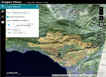
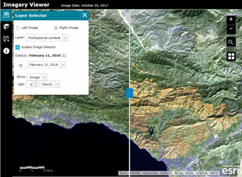
Imagery Viewer is a configurable app template for visualizing and exploring imagery through time and space, and includes tools for navigating through time, recording locations, measurement, and more. A one-image configuration lets users focus on a single imagery layer, while a two-image configuration lets users compare two imagery layers using a swipe tool.
Imagery Viewer users can do the following:
Possible use cases include:
To deploy this application, download the template repo and unzip it.
Copy the unzipped folder containing the web app template files, such as index.html, to your web server. You can rename the folder to change the URL through which users will access the application. By default the URL to the app will be http://<Your Web Server>/<app folder name>/index.html
Change the sharing host, found in defaults.js inside the config folder for the application, to the sharing URL for ArcGIS Online or Portal. For ArcGIS Online users, keep the default value of www.arcgis.com or specify the name of your organization.
"sharinghost": location.protocol + "//" + <your organization name>.maps.arcgis.comarcgis is the name of the Web Adaptor: "sharinghost": location.protocol + "//" + "webadaptor.domain.com/arcgis"If you are using Portal or a local install of the ArcGIS API for JavaScript, change all references to the ArcGIS API for JavaScript in index.html to refer to your local copy of the API. Search for the references containing "//js.arcgis.com/3.21" and replace this portion of the reference with the url to your local install.
"//webadaptor.domain.com/arcgis/jsapi/jsapi" where arcgis is the name of your Web Adaptor.Copy a group ID from Portal/ArcGIS Online and replace the default group ID in the application's default.js file. You can now run the application on your web server or configure the application further.
Read instructions for making make the configurable template available through your organization.
Note: If your application edits features in a feature service, contains secure services or web maps that aren't shared publicly, or generate requests that exceed 200 characters, you may need to set up and use a proxy page. Common situations where you may exceed the URL length are using complex polygons as input to a task or specifying a spatial reference using well-known text (WKT). For details on installing and configuring a proxy page see Using the proxy. If you do not have an Internet connection, you will need to access and deploy the ArcGIS API for JavaScript documentation from developers.arcgis.com.
Find a bug or want to request a new feature? Please let us know by submitting an issue.
Esri welcomes contributions from anyone and everyone. Please see our guidelines for contributing.
Copyright 2018 Esri
Licensed under the Apache License, Version 2.0 (the "License"); you may not use this file except in compliance with the License. You may obtain a copy of the License at
http://www.apache.org/licenses/LICENSE-2.0.
Unless required by applicable law or agreed to in writing, software distributed under the License is distributed on an "AS IS" BASIS, WITHOUT WARRANTIES OR CONDITIONS OF ANY KIND, either express or implied. See the License for the specific language governing permissions and limitations under the License.
A copy of the license is available in the repository's license.txt file.


